

Village Profile
VILLAGE PROFILE SRIMULYO
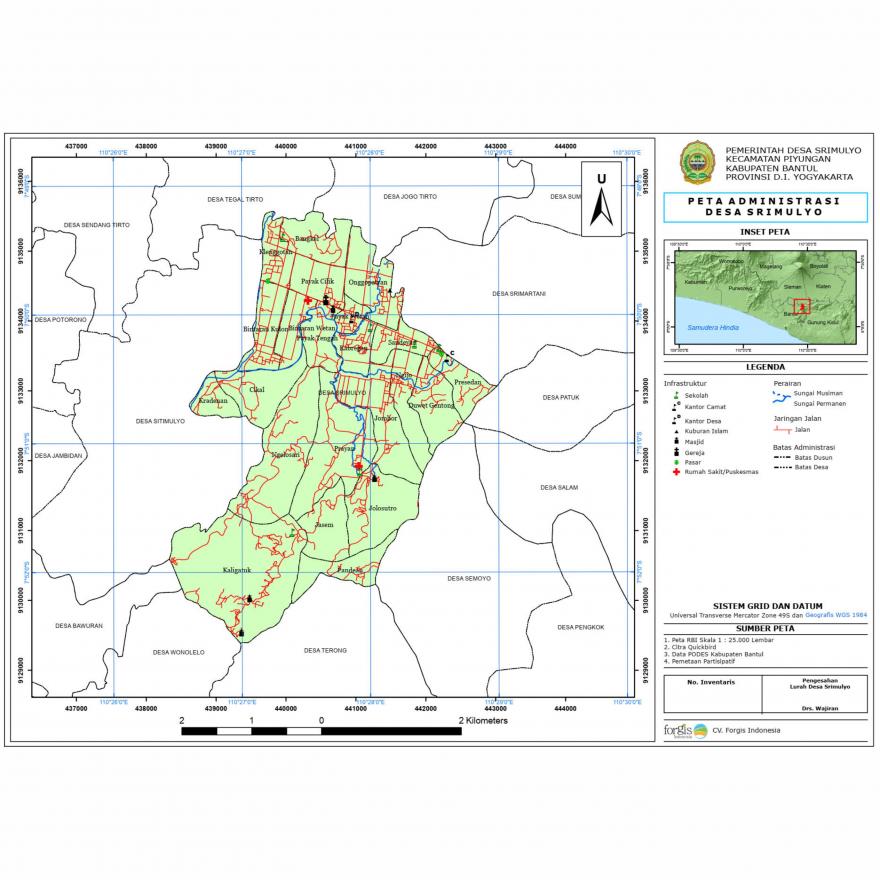
The area of Srimulyo Village has an area of 1,456,7585 ha which includes 5,4640 ha for road facilities, 573,1885 for rice fields and fields, 3,6065 ha for funerals, 2,5250 ha for industry, 5,0000 ha for shops/trade 0,2950 ha for offices, 0.4125 ha for village markets and 866,267 ha for settlements and forests. The geographical condition of Srimulyo Village is at an altitude of 110 meters above sea level, with rainfall of 2370 mm/year, located in the lowlands with an average air temperature of 23-24°C. Srimulyo Village with a fairly wide area is divided into 22 Dusun and headed by 22 chief called Dukuh.
The location of the Srimulyo Village area is very strategic, geographically Srimulyo Village is flanked and passed by 2 major rivers namely the Opak River and the Gawe River, which has a variety of land surfaces, both flat land, and mountainous land. Srimulyo Village is also traversed by Jalan Raya Yogya - Wonosari which makes traffic and transportation so dense that in the end, Srimulyo Village becomes an alternative route with 3 main routes, namely the westbound route to Yogyakarta City, the northbound route to Klaten City, and the eastbound route to Wonosari.
Srimulyo Village is administratively located in the Piyungan District in Bantul Regency, Special Region of Yogyakarta. The geographical location of Srimulyo Village is in the coordinate range of 1100 26' 26" east longitude to 1100 28' 59" east longitude and 70 49' 13" south longitude to 70 52' 34" south longitude. Srimulyo Village is one of the villages located in the easternmost part of Bantul Regency, which borders Gunungkidul Regency. Meanwhile, administratively Srimulyo Village has the following limits.
- North boundary: Tegaltirto, Jogotirto - Sleman Regency;
- Southern boundary: Wonolelo, Terong - Bantul Regency and Semoyo - Gunungkidul Regency;
- West boundary: Sitimulyo, Bawuran - Bantul Regency;
- Eastern boundary: Srimartani - Bantul Regency and Patuk, Salam, Semoyo - Gunungkidul Regency.
Based on official spatial data from the Geospatial Information Agency (BIG) corrected by the participatory mapping method involving each hamlet head, it is known that Srimulyo Village has the largest area in Bantul Regency, which is ± 1,462.33 hectares divided into 22 Dusun. Detailed information about the Srimulyo Village profile can be downloaded at the link below.
Dokumen Lampiran
Sejarah desaKirim Komentar
Komentar baru terbit setelah disetujui Admin